Orienteering on Foggy Hill
The first competition of Hong Kong Orienteering Ranking League (Middle / Long) 2016, the third full year since I become an orienteer, was held today. The event took place at Tai Mo Shan (大帽山), the highest hill in Hong Kong. As it is usually foggy on the hill, it is also called 大霧山, which means “foggy hill” and sound the same as its true name except the tone in Cantonese.
This was also the first ranking competition after I completed the lessons of level 3 orienteering course, which requires me to finish two ranking competitions scoring at least 600 afterwards in order to graduate. As I had never got 600 marks before in middle / long ranking events, this seemed to be a big challenge to me.
The weather today on the hill was, as usual, foggy to the extent that the visibility was only about 10 metres. This was certainly a good news for me, as other competitors who are physically fitter than me might not be able to run as fast as they would in normal conditions without making mistakes, which would probably increase the winning time, hence, the scores of all other competitors. However, the amount of climb in today’s course was large, as my physical fitness and cross-country ability is not good, I could not travel fast on the terrain as well.
I could handle the difficulty of today’s course using techniques learnt from the level 3 course, and also from my club’s training, like attack points, contouring and distance estimation. However, I was not free from technical mistakes.
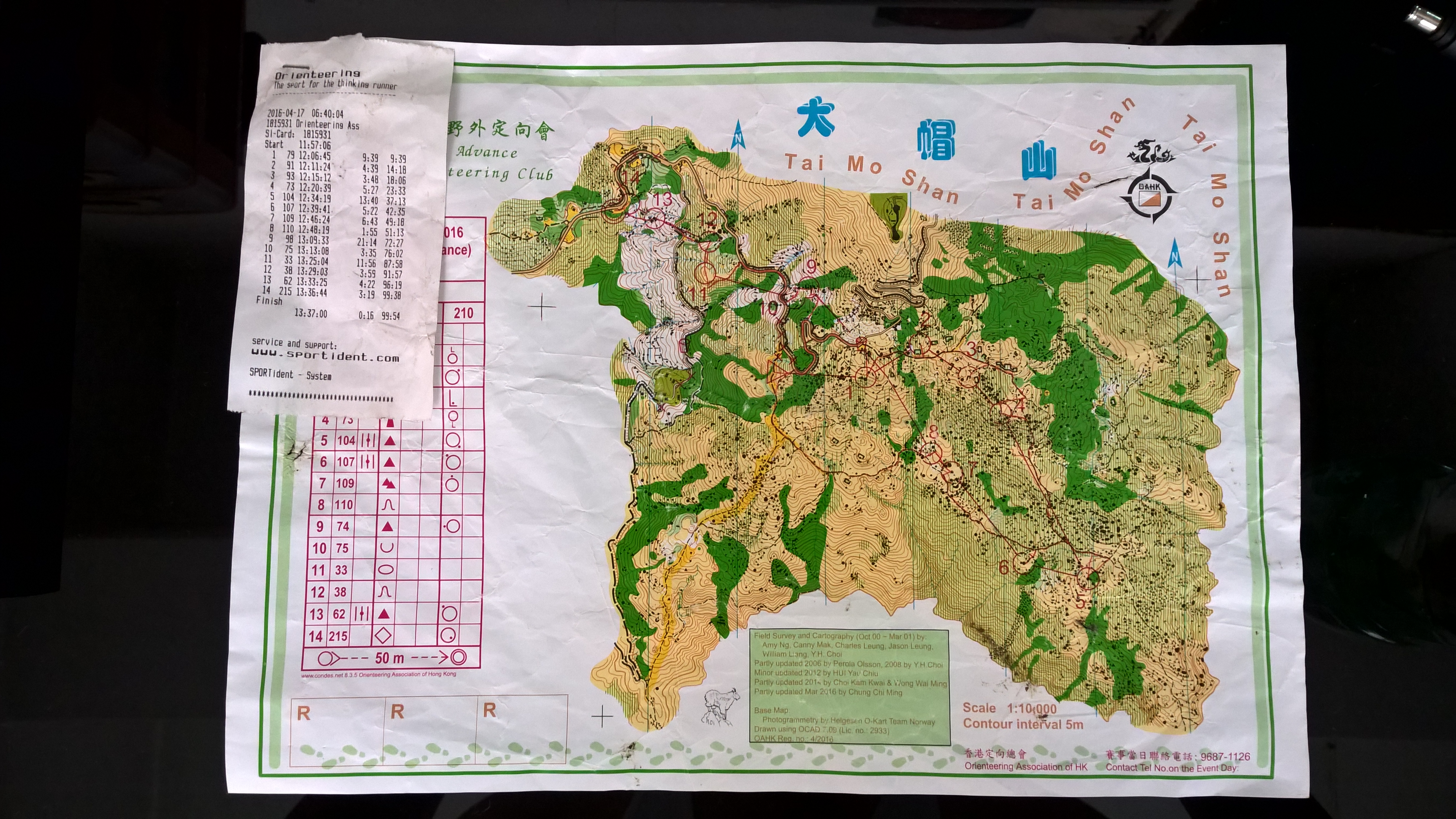
I started the race at 11:58. I immediately climbed back to the road from the start, and walked (the road is too steep for me to run) to the water station, where I could follow the remains of a fence to control 1. I returned to the track, and identified the rectangular cliff as the attack point to control 2. Then I ran the track until an intersection on the right, and entered control 3.
I returned to the track and continued in a easterly direction, until a knoll appeared on my left, where I chose that as the attack point to control 4. However, I went to the wrong rock at the north, and returned to the control from there. I then ran down the path until the intersection at the north-east of control 5, and entered the control.
I returned to the path and ran to the west. I should have run about 200 metres before I look for the spur on my left, however, I couldn’t resist my temptation to follow a large group of competitors, and left the path prematurely in the region of striped green, even I didn’t feel that I had already run for 200 metres. However, being aware of the fact that I was taking a chance, I returned to the path fast when I couldn’t match the features at the first glance, and ran to the correct one to control 6.
Controls 7 and 8 were easy. I just followed the path until the undergrowth around me disappeared, identified the depression and headed directly to the group of rocks of control 7, and then to control 8 without returning to the path.
The leg to control 9 was a long leg. I thought for about 5 minutes, whether I should use the path to the start, or to climb the spur directly to control 1 after crossing the river. However, in fact, it was difficult to climb the spur after crossing the river, so I ran along the path to start, climb onto the road like what I did to control 1, and into the forest to control 9. I then travelled down, using a large rock as the intermediate, to control 10.
The biggest mistake I made today was from 10 to 11. I ran down the road until the correct place, but I deviated from the right direction when I was slipping down the slope, resulting me in green region where I could not locate myself. I then only recognised the sound of water flowing down the river on the south, and blindly travelled to the north until I exited the dense forest, where I could find the knoll immediately. Afterwards, I contoured to control 12, ran downwards to the road, slipped on the spur to control 13, crossed the two rivers, went back to the road, punched the last control and finished the race in 99 minutes.
My calculated score today is 685, meeting my short term target of 600, and is the best in my middle-long ranking. However, a lot of my classmates in the level 3 course could not finish the competition. I hope that I can get my level 3 certificate after the HKOC sprint ranking, postponed due to unstable weather, next month. I also hope that I can get continuous improvement in the coming middle-long ranking events, by learning through today’s mistakes.